


Mini-Lesson 1: Geometric correction of an AVHRR image
Lesson Aims:The aim of this lesson is to show the limitations of a linear transform applied to an Advanced Very High Resolution Radiometer (AVHRR) image, of the Mediterranean Sea. It demonstrates the need for a quadratic transform to achieve good rectification of the image and the influence of a poor GCP on the rectification process. Objectives:You will learn how to rectify an AVHRR colour composite image using linear and quadratic transforms and compare the outputs to a georeferenced coastline image (freely available on the world-wide web) using a formula document. Download the lesson:Sample images:A selection of images from this mini lesson are shown below. |
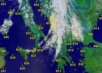
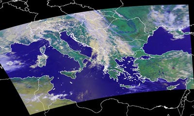
Uncorrected AVHRR colour composite image of the Mediterranean Sea and Black Sea with Ground Control Points (GCPs) superimposed. |
|
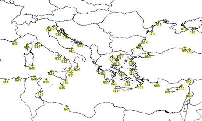
Master image of the coastline, downloaded from the US Geological Survey MapGen site, with the same GCPs superimposed. |
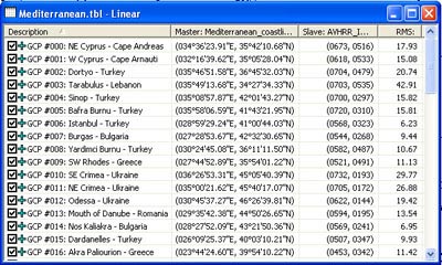
Part of the rectification table linking geographical coordinates of GCPs in the master image with row and column coordinates of the same points in the uncorrected AVHRR image.
|
|||
An attempt at rectifying the AVHRR image using a linear transform with the master image coastline superimposed to show how this fails due to the curvature of the Earth. |
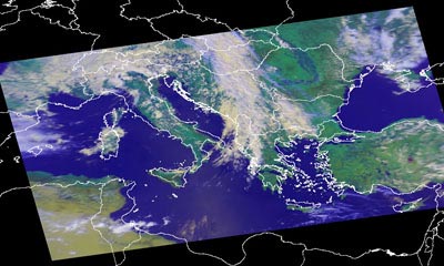
Successful rectification of the AVHRR image using a quadratic transform with the master image coastline superimposed to show how a perfect fit is obtained. Comparison with the uncorrected image shows just how distorted such a large image can be. |
| Last update: 31 January 2018 | Contact |  |
Site Policy |
Next: Mini-lesson 2

|