


5. Removing sun glint from Compact Airborne Spectrographic Imager (CASI) imagery
Author: Dr Alasdair.J.Edwards, University of Newcastle, U.K.
with support from Dr Peter Mumby and Dr John Hedley of the Marine Spatial Ecology Lab, University of Exeter, U.K.
Aim of Lesson
To learn how to rectify an image to a Universal Transverse Mercator (UTM) coordinate system and to understand why it is important to carry out geometric correction of remotely sensed images.
Learning Objectives
To understand the rationale underlying the method of sun glint removal developed by Hochberg et al. (2003) as modified by Hedley et al. (2005).
To choose a reference near infra-red (NIR) band and find out the ambient NIR signal in the absence of sun glint.
To select areas of deep water with varying sun glint intensities and find out the linear relationship (regression) between each visible band and the chosen NIR band pixels.
To use the information from 2 and 3 above to remove the component of visible band values that is due to sun glint and thus 'deglint' each pixel of the visible bands.
How to download the lesson
Lesson overview
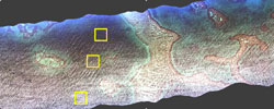
Colour composite showing the CASI image before sun glint removal. Specular reflection along wave edges is obscuring much of the image and sun glint is generally bad along the southern side of the ground-track. Three areas of deepish water showing varying sun glint are outlined by the yellow boxes.
The problem of sun glint
The mapping of benthic features can be seriously impeded by sun glinting on the water surface. Typically, sun glint forms bands of white along wave edges on the windward side of nearshore environments. These white bands confound the visual identification of bottom features, and will confuse both supervised and unsupervised classifications.
This lesson uses the modified approach of Hedley et al. (2005) to show how to remove sun glint from Compact Airborne Spectrographic Imager (CASI) imagery flown in the vicinity of the island of St John in the US Virgin Islands
The deglinting method relies on two simple assumptions:
That the signal in the NIR is composed only of sun glint and a spatially constant 'ambient' signal. In particular, there is no spatially variant benthic contribution to the NIR.
That the amount of sun glint in the visible bands is linearly related to the signal in the NIR band.
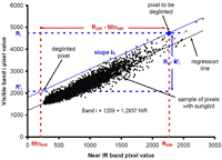
Graphical illustration of how the deglint method works. A regression is carried out between a sample of visible band (band i) pixels from areas of varying sun glint intensity and corresponding pixels in the chosen NIR band. The assumption is made that all the NIR pixels would have the 'ambient' NIR (MinNIR) value in the absence of sunglint. Knowing the slope (bi) of the regression and the value of MinNIR, you can then work out the proportionate reduction in the visible band signal (Ri) required to remove the component of the signal that is due to sun glint. This allows you to calculate a 'deglinted' value (R'i) for each visible band pixel.
The equation used to deglint each pixel is thus:
![]()
For each pixel in the image we know its NIR value (RNIR) and its value in the visible band i (Ri). We also know the 'ambient' NIR value (MinNIR). After carrying out regression analysis between selected pixels in our visible band i and the corresponding pixels in the NIR band, we know the slope of the regression line bi.
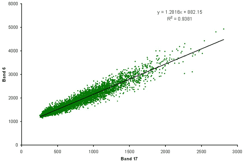
Regression of CASI band 6 (green part of the spectrum) against band 17 (near infra-red) for the three 50 x 50 pixel areas of differing sun glint intensity. For band 6 the slope of the regression line (bi in the equation) is thus 1.2816.
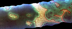
Deglinted aerial image. A colour composite showing the CASI image after 'deglinting' using a Bilko formula document. Note how bottom features are now clearly visible.
References
Hedley, J.D., Harborne, A.R. and Mumby, P.J. 2005. Simple and robust removal of sun glint for mapping shallow-water benthos. International Journal of Remote Sensing26 (10): 2107-2112.
Hochberg, E.J., Andrĕfouët, S. and Tyler, M.R. 2003. Sea surface correction of high spatial resolution Ikonos images to improve bottom mapping in near-shore environments. IEEE Transactions on Geoscience and Remote Sensing 41 (7): 1724-1729.
 Previous: Lesson 4
|
Last update: 20 August 2018 | Contact |  |
Site Policy |
Next: Lesson 6

|