Geo-location of radiance samples
Resampling to the MERIS product grid
![]()
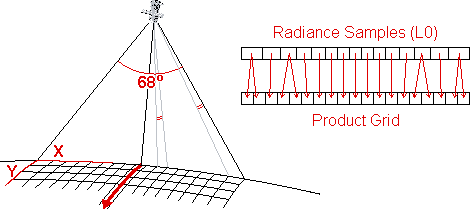
The area on the Earth's surface 'seen' by the MERIS instrument is known as its footprint. As Envisat orbits the Earth this forms a strip circling the globe, also known as the satellite swath. The width of this strip, the swath width, is determined by the sensor's field of view (FOV), which for MERIS is 68o, giving a swath width of about 1150 km.
Across the swath radiance from the Earth is sampled with a spatial resolution of 260 m at nadir, but this approaches 390 m towards the edges of the swath.
Along track the sampling is fixed by the MERIS frame time of 0.44s, and varies slightly with time and orbit altitude, around a mean of 292m.
The points where the MERIS radiance samples have been measured are determined by the projection on Earth of the line of sight of every pixel. The projection depends on
From footprint and radiance samples to MERIS product grid
Radiance samples recorded by the sensor cover a wider area near the edges of the swath than at nadir,
but pixels in the MERIS product grid are all the same width. This means that some radiance samples will give
rise to more than one pixel in the grid - particularly near the edges of the swath.
These duplicate pixels are flagged in the Level 1 product.
Each radiance sample represents an area on the Earth's surface. As part of processing from Level 0 to Level 1B, the radiance samples recorded by MERIS are relocated by nearest neighbour interpolation to the MERIS product grid, which has